


We Make Assessments Easy
overview
GeoAppraiser - Assessment Management In The Cloud
GeoAppraiser combines Assessment Administration, Computer Assisted Mass Appraisal (CAMA), Document Management, and Geographic Information System (GIS) information into one seamless product in the cloud with zero footprint. GeoAppraiser allows you to see your tax roll information and CAMA values simultaneously while viewing your parcel maps.
Stop Fighting Old Technology
As we talk with more and more Assessor’s Offices, the more we find workplaces that spend a significant amount of time fighting out-of-date systems that make everyone’s life miserable. Well, we have good news!
GeoAppraiser is built with the latest technology that allows you to seamlessly transition from your current system to our solution and finally eliminate the constant struggles your office has with the current system.
Everything You Need Without The Things You Hate!
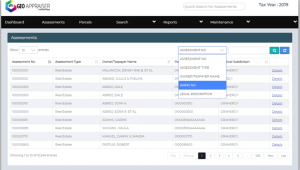
GeoAppraiser Assessments Administration allows the user to create, edit, and track values for real property (immovable), personal property (movables), and public service assessments to calculate ad-valorem taxes. All information is updated as entered, keeping tax rolls separate by each year; users can compare previous year to current year summaries.
Allows Remote Entry With Real-Time Access
The GeoAppraiser Parcels section allows the user to create, edit, and track parcel information including transfer history, legal description, parcel physical address (E911), township-range-section, ward, district, taxing body districts, subdivision-phase-block-lot, etc. All information is updated in real-time, which allows other users on the system to immediately view any changes.
GeoAppraiser Highlights
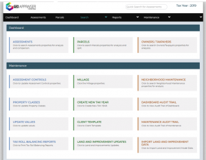
Clean Dashboard
The super clean dashboard gives you and your team easy access to all of the necessary daily functions you require. This dashboard allows you to instantly find exactly what you are looking for without wasting any time. Users can navigate through the system efficiently and effortlessly.
Assessment Administration
Administering your tax roles has never been easier. GeoAppraiser Assessments Administration allows the user to create, edit, and track values for real property (immovable), personal property (movables), and public service assessments to calculate ad-valorem taxes. All information is updated as entered, keeping tax rolls separate by each year; users can compare previous year to current year summaries.
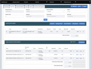
CAMA
GeoAppraiser CAMA is a Computer Assisted Mass Appraisal (CAMA) system that allows the user to evaluate improvement costs by using any one of the following: square foot, comparative unit, or income methods. CAMA seamlessly interfaces with Marshall & Swift cost tables.
The CAMA system also has a bi-directional interface with Apex for Assessors sketching software to update square footage in the CAMA application while giving Apex property owners information at the same time.
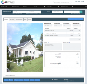
Parcel Details
The GeoAppraiser Parcels section allows the user to create, edit, and track parcel information including transfer history, legal description, parcel physical address (E911), township-range-section, ward, district, taxing body districts, subdivision-phase-block-lot, etc. All information is updated in real-time, which allows other users on the system to immediately view any changes.
State regulatory commission reports are automatically prepared using tables provided by the state. The GeoAppraiser Assessment Administration section calculates and creates tax rolls, abstract summaries, and grand recap reports.
GeoAppraiser was developed in an intuitive Internet browser environment, allowing the user to navigate the program easily out in the field on any Internet-enabled device (smartphone, iPad, tablet, etc.). Users no longer have to use the old drill-down menu method found in older systems. GeoAppraiser also has audit trail capabilities that track every change made by the users as well as a system or batch change.
Map Integration
The GeoAppraiser Map interface provides a method to link digital maps with the assessor’s or property appraiser’s tax roll. This information can include aerial photographs, digital quad maps, polygons, planimetric photos, and line-and-point geographical information systems (GIS) coverage.
Solutions
Simple. Efficient. Accurate

100% Cloud-Based
No hardware to maintain. Access your system from anywhere. Easy upgrade from a legacy system.

Configurable Administration
System is configurable to support either parcel or assessment based administration. Seamless integration with PaperVision and Apex software.

Cost & Sales Approach For Valuation
Provide both cost and sales option for accurate and mass valuation. Seamless integration with Prognose, a solution for sales approach and generate multiple comparative studies.

Marshal & Swift CoreLogic Integration
Seamless integration to get accurate valuation using M&S on button click. Integration is available for both residential and commercial valuation.

Residential/Commercial Building Data Management.
Comprehensive module to capture and maintain building data for either residential or commercial properties.

40+ Reports & GIS Integration
System supports several reports generation based on rules and regulations. Detailed break down of data for better visibility. The GIS system is embedded in the solution for graphical mapping of data.
GeoAppraiser has revolutionized our office so that we are now operating at maximum efficiency.